


1960's Tennessee "Chuckle" Map
More proof that I do things that other people would find weird, I bought this old map using some of my Christmas gift money.

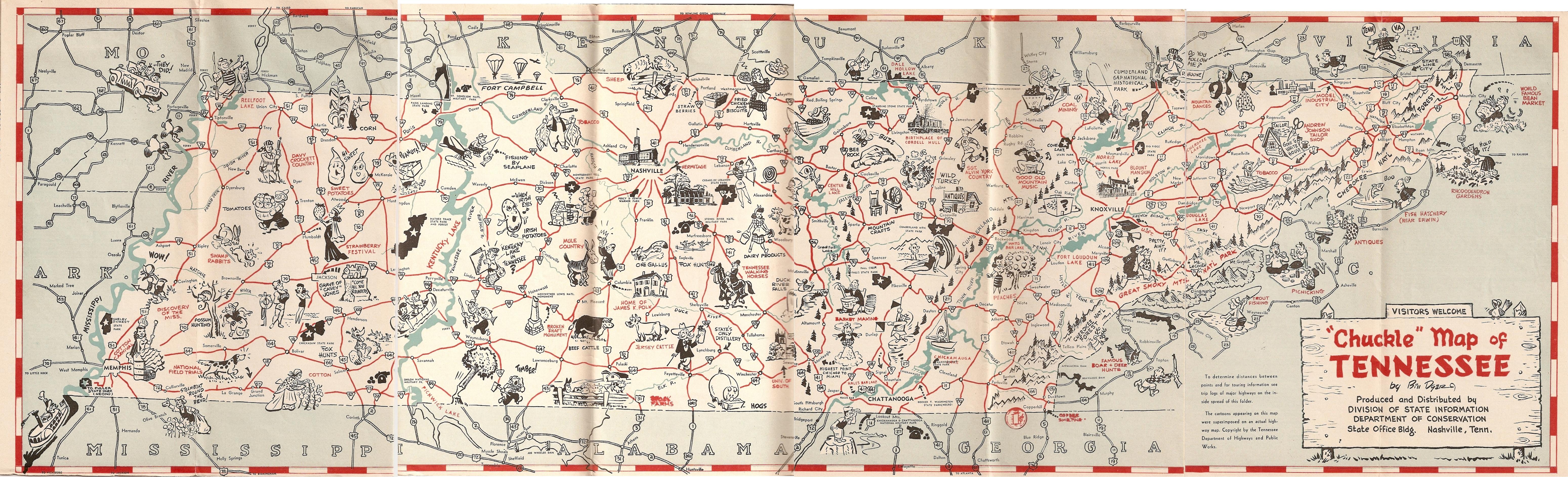
This map was apparently made in the 60's, although there wasn't a date on it anywhere. One person suggested it goes back to the 40s, but I say the 60's when looking at the population data on the back.
It's called a "Chuckle" map because it's covered with charming vignettes of different spots around the state. Examples include calling Monteagle the highest point between Chicago and Miami, singing "Irish Potatoes", Possum hunting, and the queen of the Memphis Cotton Carnival. You wouldn't see something like this printed today because it's too politically incorrect and depicts us all as hillbillies.


This is the first time I've heard Tennessee called the Nation's most interesting state. I'd agree with that, although I'm biased. It was a tourism map printed and distributed by the state, although I guess there wasn't a department of Tourism then. Instead it was produced by the Division of State Information Department of Conservation.
As you can already guess, I scanned the whole map and if you'd like to see it, here's the link: (It's quite a large image file)
http://farm4.static.flickr.com/3312/3333683867_83d9ef2079_o.jpg

I also scanned the other side, with all the text. It's good if you're curious what was considered the top tourist spots back then.


This map was apparently made in the 60's, although there wasn't a date on it anywhere. One person suggested it goes back to the 40s, but I say the 60's when looking at the population data on the back.
It's called a "Chuckle" map because it's covered with charming vignettes of different spots around the state. Examples include calling Monteagle the highest point between Chicago and Miami, singing "Irish Potatoes", Possum hunting, and the queen of the Memphis Cotton Carnival. You wouldn't see something like this printed today because it's too politically incorrect and depicts us all as hillbillies.
This is the first time I've heard Tennessee called the Nation's most interesting state. I'd agree with that, although I'm biased. It was a tourism map printed and distributed by the state, although I guess there wasn't a department of Tourism then. Instead it was produced by the Division of State Information Department of Conservation.
As you can already guess, I scanned the whole map and if you'd like to see it, here's the link: (It's quite a large image file)
http://farm4.static.flickr.com/3312/3333683867_83d9ef2079_o.jpg
I also scanned the other side, with all the text. It's good if you're curious what was considered the top tourist spots back then.
34906
posted by BrentKMoore | 8:21 PM
![]()
![]()
1 Comments:
I bought an old scrapbook at a garage sale & inside was a "Chuckle Map of TN" my husband & i have had fun looking at it. as far as the date of the map I believe it to be 1948 or 1949 as per the tn history archives & the fact that Fort Campbell is written on the map as Camp Campbell. It was officially renamed Fort Campbell in 1950.
Post a Comment
<< Home